给定两个标记点的地址,格式化处理两个点的数据,添加颜色什么的其他的属性

y***@163.com
- 发布:2020-07-08 17:19
- 更新:2023-10-23 14:14
- 阅读:1733
产品分类: uniapp/App
PC开发环境操作系统: Windows
PC开发环境操作系统版本号: window 10
HBuilderX类型: 正式
HBuilderX版本号: 2.6.16
手机系统: Android
手机系统版本号: Android 10
手机厂商: 华为
手机机型: huawei meta 20
页面类型: nvue
打包方式: 云端
项目创建方式: HBuilderX
操作步骤:
预期结果:
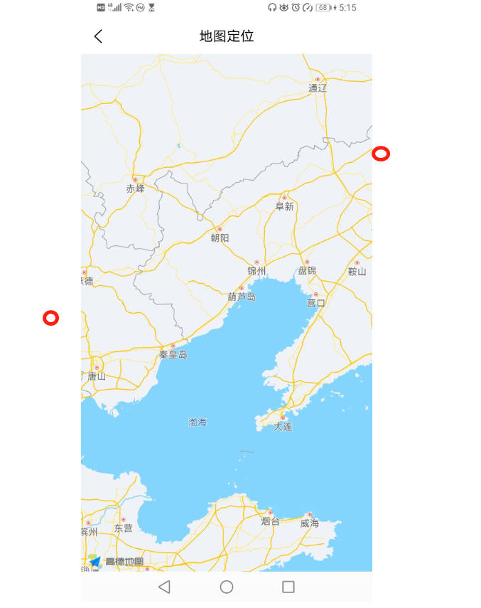
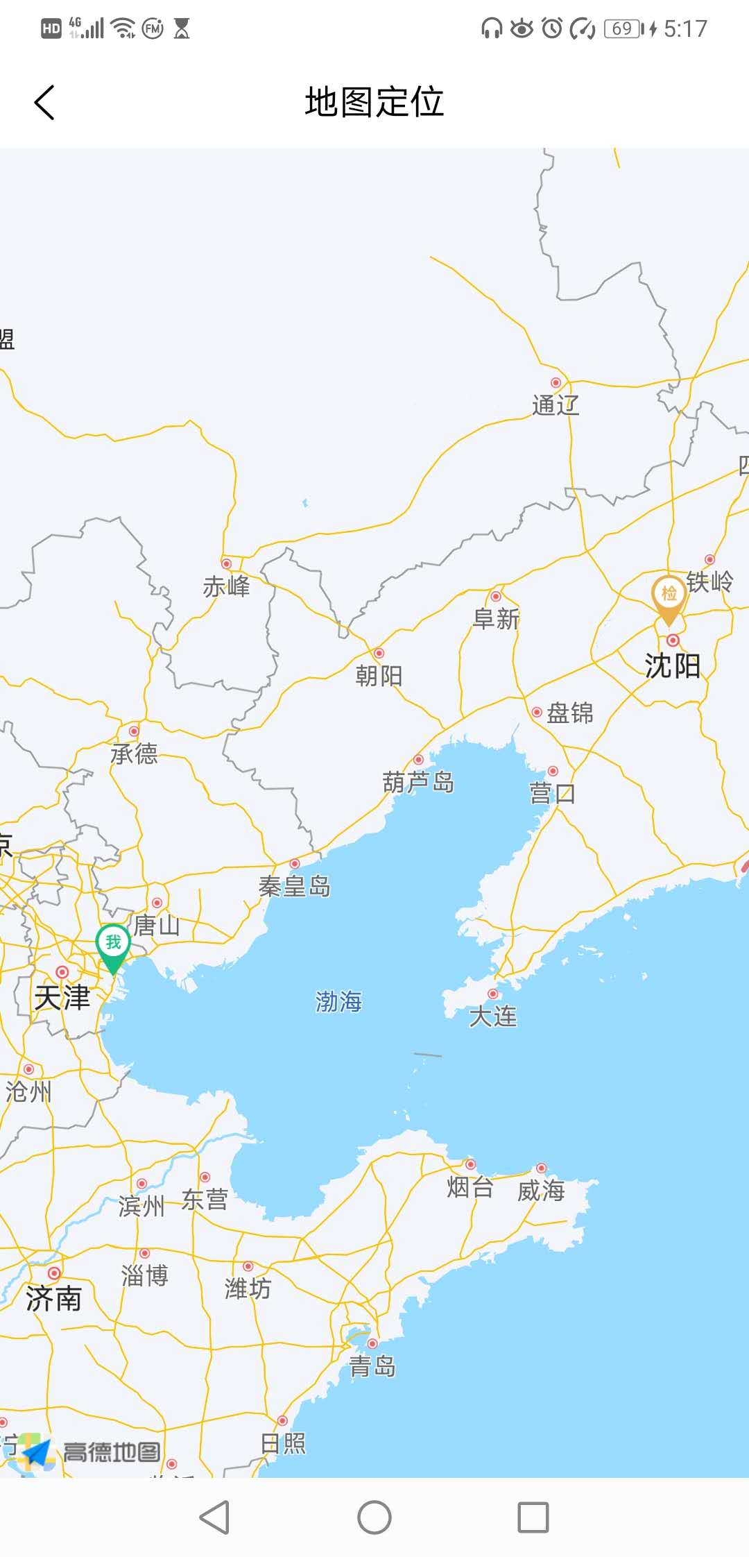
标记点都在视野范围内,不需要手动缩放
标记点都在视野范围内,不需要手动缩放
实际结果:
视野范围内没有这两个点,需要手动调整缩放尺寸才能显示
视野范围内没有这两个点,需要手动调整缩放尺寸才能显示
bug描述:
<template>
    <view class="content">
      <view v-if="type === '1'">
            <map
                id="detailMap"
                class="map-detail"
                :latitude="old_latitude"
                :longitude="old_longitude"
                :scale="distance ? 15 : 9"
                :circles="old_circles"
                :include-points="includePoints"
                :markers="old_covers">
            </map>
            <!--     :include-points="includePoints"  :scale="distance ? 15 : 9"-->
       </view>
    <view>{{pointInfo}}</view>
    </view>
</template>

<script>
    import config from '@/config/config.js';
    import url from '@/config/url.js';
    import { Base64 } from 'js-base64';

    module.exports = {
        components: {

        },
        onLoad() {
            // point-type 0 获取定点,1 显示详细

            this.type = uni.getStorageSync('point-type')

            this.distance = uni.getStorageSync('type_valueName') === '正常'
            console.log("this.distance", this.distance)
            if(this.type === '0'){
                this.getPoint()
            } else if(this.type === '1'){
                this.getDetail();
            }
        },
        onUnload() {
            uni.removeStorageSync('point-type')
            uni.removeStorageSync('checkPoint_detail')
        },
        data() {
            return {
                latitude: 39.909,
                longitude: 116.39742,
                covers: [],
                mapName: '', // 地址
                type: '', // 地图类别
                old_latitude: null, // 回显维度
                old_longitude: null, // 回显经度
                old_covers: [],
                isShow: false,
                circles: [],
                old_circles: [],
                pointInfo: '',
                includePoints: [],
                // 两点距离状态
                distance: true,
            };
        },
        methods: {
            getDetail(){
                let checkPoint_detail = uni.getStorageSync('checkPoint_detail');
                if (checkPoint_detail.length == 1) {
                    checkPoint_detail = checkPoint_detail[0]
                    this.formatOnePoint(checkPoint_detail)
                } else if (checkPoint_detail.length == 2){
                    this.formatTwoPoint(checkPoint_detail)
                }
            },
            formatOnePoint(detail_info){
                this.old_covers = [{
                        id:"001",
                        width: 40,
                        height: 40,
                        iconPath: '../../static/map/check.png',
                        latitude: detail_info.latitude,
                        longitude: detail_info.longitude,
                        title: '检查点'
                    }
                ]
                this.old_latitude = detail_info.latitude;
                this.old_longitude =  detail_info.longitude;
                let old_circles = [{
                    latitude:  detail_info.latitude,
                    longitude: detail_info.longitude,
                    color: '#EBB14C',
                    fillColor: 'rgba(235, 177, 76, 0.11)',
                    strokeWidth: 1,
                    radius: 1000
                }]
                this.old_circles = [...old_circles]
            },
            formatInfo(info) {
                let owncircles = [{
                    latitude:  info.latitude,
                    longitude: info.longitude,
                    color: '#29CA85',
                    fillColor: 'rgba(41, 202, 133, 0.11)',
                    strokeWidth: 1,
                    radius: 1000
                }]
                this.circles =  [...owncircles];
                this.latitude = info.latitude;
                this.longitude = info.longitude;
                let ownLocation =  [
                    {
                        id:"001",
                        width: 40,
                        height:40,
                        iconPath: '../../static/map/myLocation.png',
                        latitude: info.latitude,
                        longitude: info.longitude,
                    }
                ]
                this.covers = [...ownLocation]

                //  #ifdef APP-PLUS
                console.log('ddddd');
                const {city,district, street, streetNum, poiName} = info.address;
                this.mapName = `${city} ${district} ${street} ${streetNum} ${poiName}`
                console.log('当前位置的经度:' + info.longitude);
                console.log('当前位置的纬度:' + info.latitude);
                console.log('位置:' + poiName);
                console.log(this.covers);
                //  #endif
            },
            formatTwoPoint(twoPoint) {
                this.old_covers = twoPoint;
                this.includePoints = [{
                       latitude: this.old_covers[0].latitude,
                       longitude: this.old_covers[0].longitude,
                    },
                    {
                       latitude: this.old_covers[1].latitude,
                       longitude: this.old_covers[1].longitude,
                    }
                ];
                console.log('this.include_points',this.includePoints)
                // 以提交点位中心点
                this.old_latitude = this.old_covers[0].latitude;
                this.old_longitude = this.old_covers[0].longitude;
                // 添加圆圈属性
                let old_circles = [{
                    latitude:  this.old_covers[0].latitude,
                    longitude: this.old_covers[0].longitude,
                    color: '#29CA85',
                    fillColor: 'rgba(41, 202, 133, 0.11)',
                    strokeWidth: 1,
                    radius: 1000
                },
                {
                    latitude:  this.old_covers[1].latitude,
                    longitude: this.old_covers[1].longitude,
                    color: '#EBB14C',
                    fillColor: 'rgba(235, 177, 76, 0.11)',
                    strokeWidth: 1,
                    radius: 1000
                }]
                this.old_circles = [...old_circles]
            }
        }
    }
    </script>
y***@163.com (作者) - 小白一只
ip 地址可以用这个例子
[{
latitude: 39.989631,
longitude: 116.481018,
},
{
latitude: 39.9086920000,
longitude: 116.3974770000,
}
];

解决了吗?能分享一下吗?
-
-
回复 y***@163.com: 我是自己计算的scale值你有兴趣可以参考一下,显示不是很精确,但是也算是解决了这个问题https://blog.csdn.net/qq_40792558/article/details/107694048
2020-07-31 16:32


h***@hompe.com.cn - yangguang
this.mapCtx.includePoints({
points: this.covers,
padding:[80,80,80,80],
success: (res) => {
util.print('includePoints', res);
},
fail: (err) => {
util.print('includePoints', err);
}
})